Creating your own golf course map is one of the most powerful things you can do to improve your scores. This isn't just about knowing yardages, it's about building a personalized playbook that turns course management from a vague idea into a tangible strategy you can hold in your hand. This guide will walk you through the entire process, step-by-step, showing you how to build a map that's tailored specifically to your game.
Why a Custom Map is a Game-Changer
Before we get into the "how," let's talk about the "why." You might have a GPS watch or a rangefinder, and those are great tools for getting a number. But they don't tell you the whole story. A store-bought yardage book gives you basic information, but it doesn’t know your game. It doesn’t know you tend to miss left with your long irons or that your 150-yard club is actually your 8-iron, not your 7-iron.
Making your own course map forces you to think like a professional. You’ll stop seeing a hole as just a tee, a fairway, and a green. Instead, you'll start seeing it as a series of strategic decisions. You'll identify smart target lines, safe landing zones, and "no-go" areas that lead to big numbers. When you stand on a tee box with your own custom map, you're not just a golfer, you're a strategist who is prepared for every shot.
Step 1: Gather Your Mapping Tools
You don't need expensive software or a design degree to create a professional-quality course map. In fact, you probably have everything you need already. Your primary tool will be Google Earth Pro. Don't confuse this with the browser-based Google Maps or Google Earth. You’ll want to download the free desktop application called "Google Earth Pro." It gives you incredibly useful features for golf mapping, including:
- High-resolution satellite imagery
- A "Ruler" tool for pinpoint accurate distance measurements
- The ability to tilt and rotate the view to see the hole exactly as you would from the tee box
Besides Google Earth Pro, you'll just need a few other simple tools:
- A Screenshot Tool: Every computer has one built-in. This is for capturing your bird's-eye images of each hole.
- A Basic Graphics Program: This doesn't need to be fancy. Microsoft PowerPoint, Google Slides, or even a free online tool like Canva are perfect for adding lines, shapes, and text to your screenshots.
- A Printer and Notepad (Optional): If you prefer to go the old-school analog route, you can print the hole images and draw your notes by hand. Colored pens can be very useful here.
Step 2: The Reconnaissance Phase - Capturing Your Course
This is where the fun begins. You're about to become an expert on every inch of your home course. We'll capture the raw layout of each hole, which will become the foundation of your strategic map.
Find Your Course and Get Positioned
Once you have Google Earth Pro installed and open, simply type the name of your golf course into the search bar. The software will fly you right to it. Zoom in until you can clearly see the layout of the first hole.
From here, you want to line up the view as if you're standing on the tee box. Use the navigation controls (or your mouse) to rotate the map and tilt the angle so that you're looking from the tee box directly toward the green. Try to frame the shot so you can see the entire hole, from your main teeing ground to behind the green.
Take a Screenshot of Every Hole
Repeat this process for all 18 holes. Take a clean screenshot of each one, making sure you capture all the relevant features like doglegs, bunkers, and water hazards. Save these images in a dedicated folder, naming them "Hole 1," "Hole 2," etc. This library of images is the canvas for your project.
Import Your Canvases
Now, open your program of choice (like PowerPoint or Google Slides). Create a new document and start a new slide for each hole. Import your "Hole 1" screenshot onto the first slide, your "Hole 2" screenshot onto the second, and so on. Now you're ready to start mapping.
Step 3: Marking the Essentials - The Distance Framework
This is where your map starts to become a powerful tool. Using Google Earth Pro's "Ruler" tool, you're going to layer in all the vital distance information. The ruler lets you measure between any two points on the map.
For each hole, switch back to Google Earth Pro and get ready to measure. On your PowerPoint slide for that hole, you'll replicate these measurements with text boxes and lines.
Your Core Distance Measurements
From the tee box you most frequently play, measure and mark the following:
- Distance to Front, Middle, and Back of the Green: These three numbers are the most basic and essential pieces of information for every approach shot.
- Carry Distance Over Hazards: How far is it to carry the front bunker? What number do you need to fly that creek running across the fairway? Mark this clearly.
- Distance to Reach Hazards: Just as important is knowing the distance to the front of a fairway bunker or the edge of a water hazard. This helps you decide to lay up. For example, if a bunker starts at 240 yards and your driver goes 250, you know pulling the big stick is a risky play.
- Ideal Lay-up Distances: Mark key yardage points in the fairway, like 150 yards and 100 yards out from the green. These become your targets when you can't or don't want to go for the green.
Step 4: Adding Your "Player's Edge" - The Strategy Layer
With the distances locked in, this is the part a GPS watch can't do. You're now going to add the strategic layer that is completely customized to your game, your tendencies, and your shot shapes. This transforms the map from a simple yardage guide into a Caddie-in-your-hand.
1. Draw Your Ideal Lines
Use the line tool in your software to draw the perfect shot you hope to hit. On a dogleg right, this might be a subtle fade that starts down the left-center of the fairway and curves toward the hole. On a straight par 4, maybe your ideal tee shot is just aimed at the big oak tree in the distance. Visualizing the shot shape on the map hardwires it in your brain.
2. Mark Your "Personal" Carry Numbers
Be honest with yourself about how far you carry your driver and 3-wood. Let's say you've told yourself for years you carry your driver 250 yards, but a fairway bunker that's 240 yards out seems to catch your ball constantly. Your map is the place for truth. Draw a line or circle at your real carry distance. This builds trust in your club selection.
3. Identify The Bail-Out Areas
Every hole has a "safe" place to miss. On a par 3 surrounded by water, the safe miss might be short and to the left, leaving an easy chip. On your map, use a green circle or box to highlight these bail-out zones. This gives you a confident plan B when you're not feeling great over a shot.
4. Expose the "No-Go" Zones
This might be the most valuable part of the map. Use red shading or a big red "X" to mark the places that absolutely kill your score. Is there a bunker that's particularly deep? Red X. Is there out of bounds right that perfectly matches up with your slice miss? Red X. By explicitly identifying these areas, you train your brain to steer clear of them automatically.
5. Add Green Details and Personal Notes
While you can't get perfect green contour data, you can add simple but effective notes. Use arrows to show the general slope direction (e.g., "Slopes hard back to front"). Add notes like "Short is always better than long here."
Finally, add personal clubbing reminders. On a hole that's often into the wind, add a note: "Always take one extra club." On a downhill par 3, remind yourself: "Plays one club less." These small notes prevent you from making silly mental mistakes on the course.
Step 5: Assemble Your Personalized Yardage Book
Once you've mapped all 18 holes, it's time to create the final product. The easiest way is to print out each slide. You can fit two or four holes to a standard sheet of paper.
Cut them out and organize them in order. You can staple them together on the side to create a simple booklet, or use a small three-ring binder notebook. The goal is to make something that fits easily in your back pocket or your golf bag. Hold it, flip through it - this is your masterpiece. It’s a physical representation of your plan to beat the course.
Final Thoughts
Making your own course map connects you to your game on a much deeper level. The process forces you to confront your tendencies, get honest about your distances, and build a real, actionable strategy for playing smarter golf and avoiding costly mistakes.
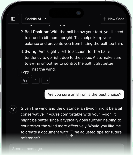
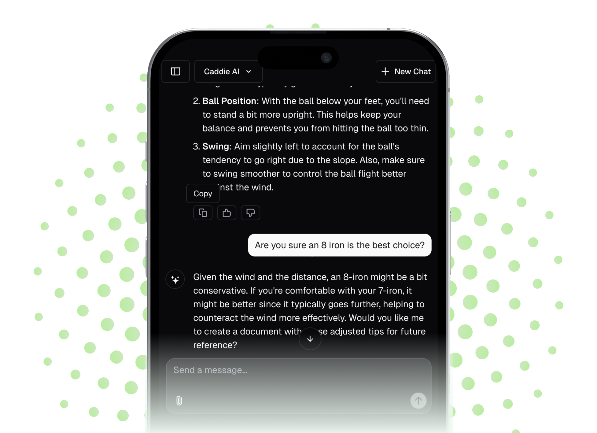
While a handmade map is an incredible tool for pre-round planning, the game is full of unexpected situations. That's where technology can complement your preparation. When you find yourself in an awkward lie not on your map, or when the wind suddenly whips up, you need a dynamic solution. To help with this, we developed Caddie AI to give you that expert second opinion for any shot, right in your pocket. You can even take a photo of a tricky lie in the rough and get instant, smart advice on how to play it, bridging the gap between your plan and the reality of the game.